
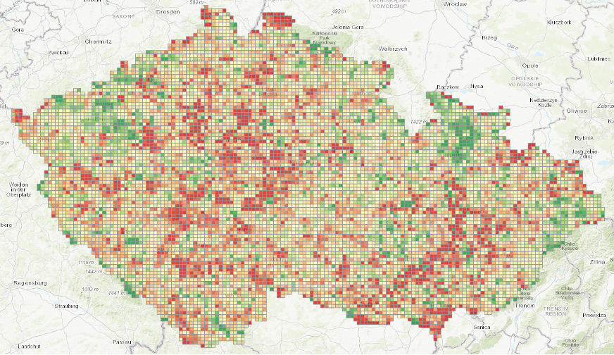
Biodiversity policy is always about places: where habitat is restored, where management changes, and where new biodiversity-supporting areas are created. But public support for these actions can also be spatial—shaped by where people live, what nature they have around them, and the spatial configuration of proposed interventions (for example, how far away they are).
A new open-access paper in Resource and Energy Economics introduces and tests a novel, national-scale, spatially explicit stated choice experiment designed to capture this reality by letting respondents evaluate real locations across the Czech Republic. The article is part of special issue REE / JEEM Workshop on Nonmarket Valuation.
Full paper: Badura and Schaafsma (2026) “Incorporating spatial complexity and variability into the design of stated choice experiments for biodiversity policy support” DOI: 10.1016/j.reseneeco.2026.101565
What we did
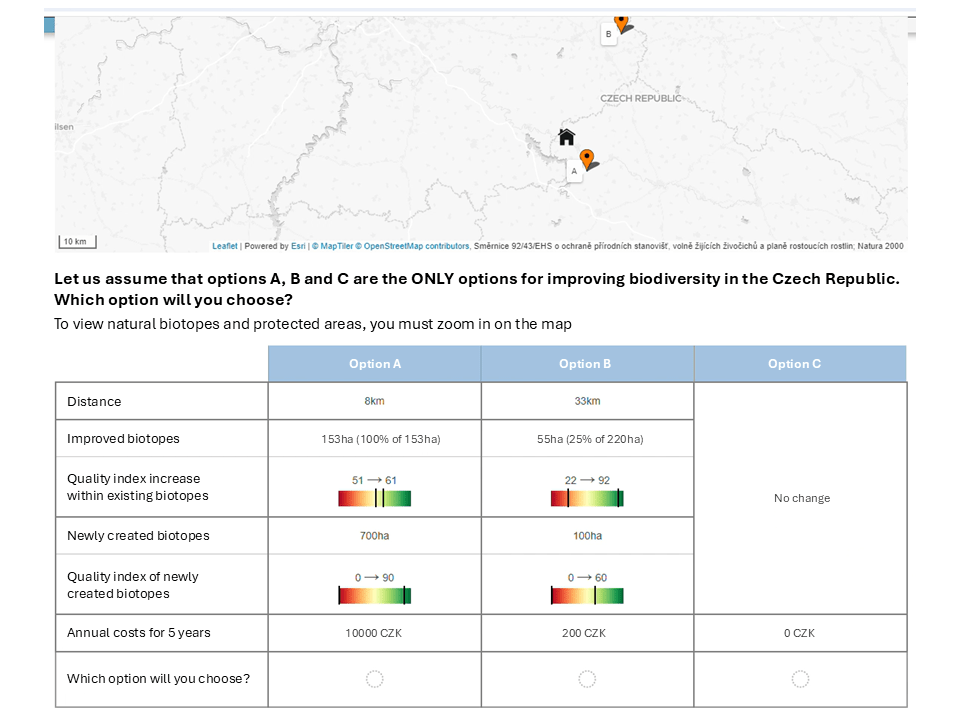
We combined a large GIS database of potential biodiversity policy sites with a survey functionality specifically developed to generate realistic, respondent-specific, map-based choice tasks. In each task, people choose between two policy options (A and B) and a “no change” option—but crucially, A and B are actual locations displayed on a map, together with the respondent’s home location.
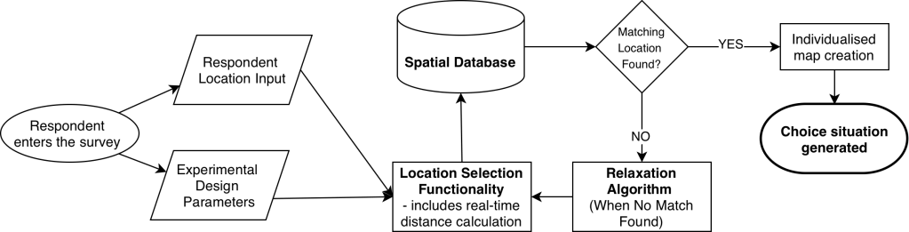
To keep experimental control—so we can systematically vary spatial and non-spatial characteristics while still using real sites—an algorithm selects locations that match the target levels from the experimental design (including distance). When an exact match is not possible, the algorithm relaxes constraints step-by-step to find the closest feasible sites. Together, this functionality (see figure 2) makes choices more realistic while creating a unique dataset with substantial variation in spatial factors, enabling us to study spatial effects at national scale.
What is novel is the combination of national scale and realism: thousands of real candidate sites and respondent-specific maps generate unusually rich variation in spatial factors (especially distance, but also other location characteristics) while still preserving the structure of experimentally controlled choice situations.
Key findings
- Location matters for public support of biodiversity interventions.
- Distance matters, but not in a simple or uniform way.
- How spatial factors are accounted for changes the estimated “distance effect”. Different spatial specifications can lead to different interpretations of how distance shapes preferences.
- Large, high-quality biodiversity improvements can retain public support even at greater distances.
The broader takeaway is methodological: instead of treating space as background context, the paper shows how spatial determinants can be embedded directly into the design of a stated preference study—enabling spatial analysis at national scale. A next step is to use this approach to develop spatial prioritisation maps that can support policy advice.
Open science
The article is open access. Data and code are available upon request.
Funding:
This project has received funding from the European Union’s Horizon 2020 research and innovation programme under the Marie Skłodowska-Curie grant agreement No 101030693 (Spatial non-market Valuation for Biodiversity policy – SVAB) at VU Amsterdam. Additional funding for data collection was provided by the Integrated LIFE project for Natura 2000 in the Czech Republic, LIFE-IP: N2K Revisited (One Nature), LIFE17 IPE/CZ/000005. Finally, this publication is also the outcome of the project “Spatially Explicit & Plural Valuation for Just Biodiversity Policy – SPValues” (PRIMUS/25/SSH/006) realised at the Charles University Environment Centre.


Leave a comment